

The eight knowledge areas of geospatial computing
(Part 2)

The saga continues! Welcome back for Part 2 in this mini-series, where we cover the eight core knowledge areas of geospatial computing. These knowledge areas, sitting at the intersection of computational science and geospatial science, include:
Cyberinfrastructure
Parallel Computing
Big Data
Computational Thinking
Interdisciplinary Communication
Spatial Thinking
Geospatial Data
Spatial Modeling and Analytics
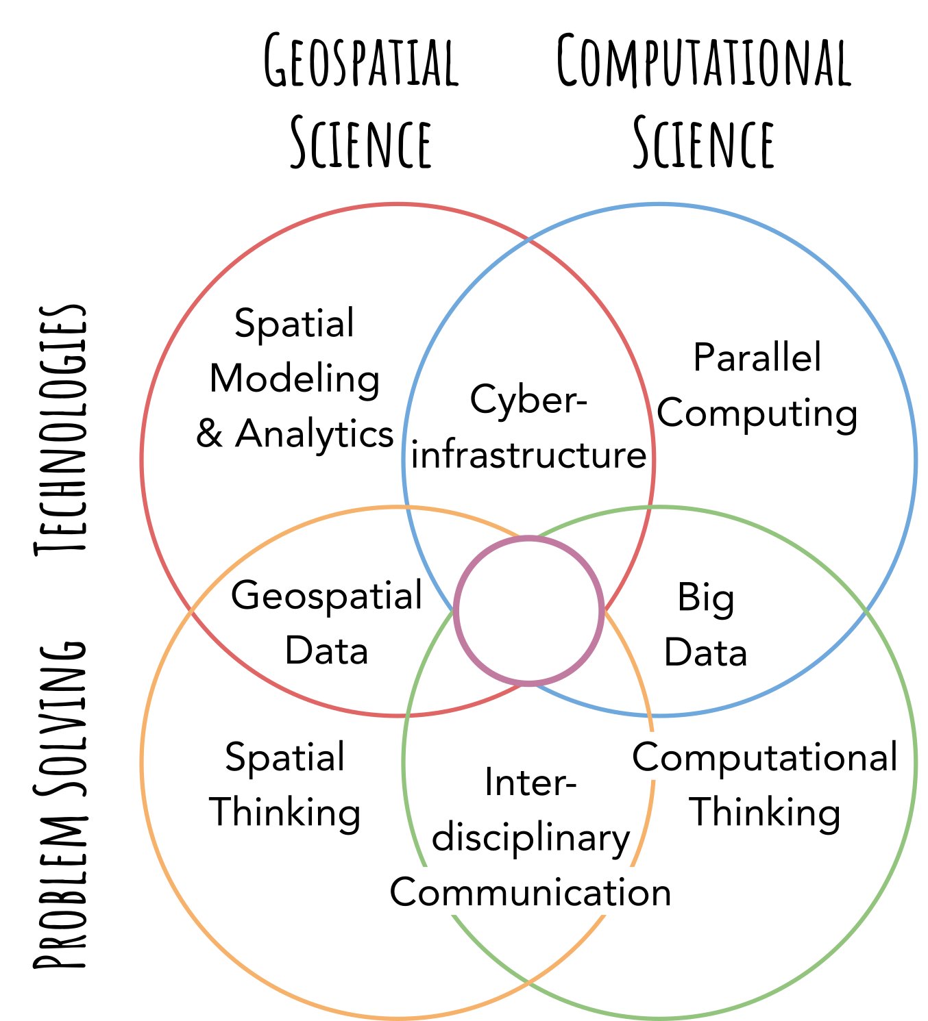
In Part 1, we covered the four knowledge areas primarily sitting on the computational side. However, if you missed it, you could check out the eight core knowledge areas of geospatial computing (Part 1). This week we will focus our attention on the geospatial side.
Interdisciplinary Communication
This knowledge area can be considered the least technical but perhaps the most important. Communication of information and ideas is paramount in collaborative problem-solving endeavors in science or industry. However, how we communicate may differ.
When we communicate with our peers, we use jargon, include detailed descriptions, and can assume certain levels of background knowledge. We might communicate differently with individuals and groups with different backgrounds, areas of expertise, and even attention levels (e.g., stakeholders, bosses, customers, etc.). Geospatial computing frequently spans technical groups (e.g., developers, DevOps, database administrators) and non-technical groups, including users and stakeholders. Knowledge and the ability to abstract, relate, build metaphors, and create analogies are all powerful ways to communicate across different disciplines by creating a shared language.
We can also use geospatial technology as a communication medium. StoryMaps. An easy-to-use platform that allows anyone to tell their story using maps. Computational notebooks are another way to narrate your data story. Data scientists can explain their code, analyses, models, and results in the notebook. Ethics, privacy, and intellectual property topics are embedded within this knowledge area.
Check out the "Links of the Week." This new addition is waiting for you at the bottom of the newsletter. This week's links are highly related to the topics in this area.
Spatial Thinking
Congratulations if you moved across the room and did not run into any furniture because you applied spatial thinking. Of course, spatial thinking is a bit bigger than that. Spatial cognition and understanding spatial relations sit at the core of this knowledge area. Connecting spatial phenomena by distance, direction, topology, and time helps us understand how spatial relationships operate. A confounding factor in this type of thinking is uncertainty in context and spatial scales. For example, the Modifiable Areal Unit Problem (MAUP) is a classic challenge in geospatial science that we must consider in many scenarios.
One challenge I have encountered in this area is scale. High-resolution data covering vast spatial extents has forced me to look at both large- and small-scale processes. You cannot escape. You mentally connect the tiny with the huge. However, it can be humbling once you genuinely appreciate the vastness of the globe. It is my way of bringing "proportionality, like a cosmic right-sizing" to my life. * I am reimagining the words of BJ Miller in his famous TED talk here.
Geospatial Data
Ah, geospatial data. Here professionals usually jump directly to the two standard spatial data models: raster (two-dimensional grids of pixels) and vector (points, lines, and polygons) and projection systems. In geospatial computing, it is essential to consider how we capture geospatial data, represent it, and transform it into geospatial information. Geographic Information Systems (GIS) are the standard ways of handling geospatial data because it makes it so easy. One trap, especially for Geographic Information Scientists, is losing focus on the problem. Information scientists love to focus on the data rather than what the data illuminates. So we spend much time and attention on data representation rather than data transformation. The curse of knowledge can limit our thinking and problem-solving because we can box ourselves into traditional ways of solving problems using GIS. After all, it is easy, rather than going beyond geographic information and examining other possible solutions using geospatial computing.
Spatial Modeling and Analytics
This knowledge area includes spatial analysis, spatial statistics, and spatial data mining. Machine and deep learning are also in this knowledge area. Importantly, this is where professionals can process (big) geospatial data. Again, here is a growing area where advances are creating new models and methods. From GeoAI to agent-based models (ABMs), we see more complex ways to not only process data but also generate data and test theories and alternative scenarios that would be impossible to try in the real world.
Next week we will look at the dimensions and intersections of these areas. Like how we can combine spatial modeling and analytics with parallel computing to handle big geospatial data!
I'm trying something new in this newsletter. In addition to the essay, I wanted to add a few "links of the week." These are a few resources I found insightful and interesting and wanted to share with the Globe to Gates group. So if you see something interesting, please send it my way to share with the group! I will make sure to give you a shout-out!
Links of the week
The Golden Age of Geography, Forbes, Jack Dangermond
This a lovely piece illustrating how the knowledge areas can come together. Cutting-edge technology, computing power, maps as a communication medium, interdisciplinary communication across business and government, and lots of geospatial data.
https://www.forbes.com/sites/esri/2022/09/15/the-golden-age-of-geography/?sh=72a39638cd79
GIS Ethics Case Studies, Penn State
Geoethics is a burgeoning topic. The GIS Ethics Case Studies below are a great way to help all of us dive into this topic.
Blue Print for an AI Bill of Rights, White House
The White House announced this blueprint in October 2022 that outlines several key topics: safe and effective systems, algorithmic discrimination protections, data privacy, among others. It is worth a read.
Last but not least. It is cooling down here in Minnesota. The fall leaves are yellow, orange, and flaming red. So this is just a personal reminder to go outside, enjoy the weather, and explore your little piece of the globe.